Vallam Kali - Boat race

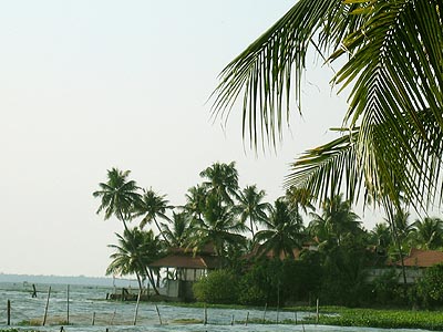
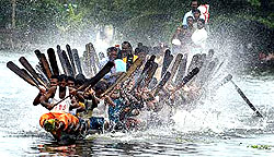
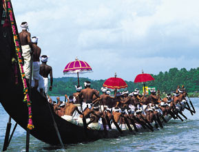
Kerala, especially Alappuzha is famous for Snake Boats or locally cally Chundan Vallams. Snake boat races (chundan vallam kali) is normally conducted during Kerala's main festival (Onam) season.

Snake boats are constructed in wood with a lenght of 100 to 160ft and the rear portion towering to a height of 20ft. Normally a snake boat can contain up to 128 oarsmen including 4 main orsmen holding pankayam and who directs the boat. There will be few singers and a capain.

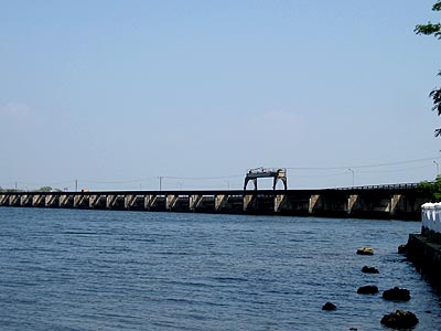
Main boat races in kerala are Nehru Trophy boat race, Payippad vallam kali, Chambakkulam moolam vallam kali, Karuvatta leading channel boat race etc
It is mainly conducted during the season of the harvest festival Onam in Autumn. Vallam Kali include races of many kinds of traditional boats of Kerala. The race of Chundan Vallam (snake boat) is the major item. Hence Vallam Kali is also known in English as Snake Boat Race and a major tourist attraction. Other types of boats which do participate in various events in the race are Churulan Vallam, Iruttukuthy Vallam, Odi Vallam, Veppu Vallam (Vaipu Vallam), Vadakkanody Vallam, [[Kochu Vallam.

The most renowned of these races
Nehru Trophy Boat Race
Champakulam Moolam Boat Race
Aranmula Uthrattadi Vallamkali
Payippad Jalotsavam, The Oldest Snake boat race.
Kumarakom Boat Race
Indira Gandhi Boat Race, at Ernakulam lake.

Nehru Trophy Boat Race is a popular Vallam Kali held in the Punnamada Lake near Alappuzha, Kerala. Vallam Kali or Vallamkali literally means boat play/game, but can be translated to boat race in Malayalam. The most popular event of the race is the competition of Chundan Vallams (Snake Boats). Hence the race is also known as Snake Boat Race in English. Other types boats which participate in various events of the race are Churulan Vallam, Iruttukuthy Vallam, Odi Vallam, Veppu Vallam (Vaipu Vallam), Vadakkanody Vallam and Kochu Vallam.

The race conducted on the second Saturday of August every year is a major tourist attraction.
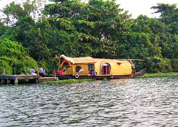
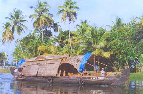
Chundan Vallam (Chundan boat) known to outside world as Kerala snake boats is one of the icons of Kerala culture used in Vallamkali (boat race).

Constructed according to specifications taken from the Sthap Athya Veda, an ancient treatise for the building of wooden boats. These boats are about 100 to 138 ft in length, with the rear portion towering to a height of about 20 ft. and a long tapering front portion. It resembles a snake with its hood raised. Its hull is built of planks precisely 83 feet in length and six inches wide. Aries Punnamada Chundan, an initiative of the Aries Group of Companies, is widely acclaimed to be the longest Snake Boat with a length of 144 ft. It is also the first Snake Boat to be constructed in steel.

Sabarimala

Sabarimala (0929 North 7706 East) is situated in the midst of 18 hills, in a bowl of land blessed with a small rivulet named `Urakuzhi Theertham'. The area is in the hilly regions east of Kerala bordering Tamilnadu. Elevation above mean sea level is approximately 1260 Metres/4135 Ft. Temples existed in each of the hills surrounding Sabarimala. While functional (and intact temples) exist at many places in surrounding areas like Nilackal, Kalaketi, Inchiparakotta and Karimala, remnants of old temples are visible in the remaining hills.

From the international airport of Thiruvanathapuram (erstwhile Trivandrum), Sabarimala is located at 010 degrees/115 Kms. Similarly, from the international airport at Kochi (erstwhile Cochin) it is located at 118 degrees/106 Kms. These distances are `direct air distances or distances `as the crow flies'.

The pilgrimage to Sabarimala is a singular example of a pilgrimage where pilgrims, without consideration of caste, creed, position or social status, go with one mind and one `mantra' dreaming constantly of the darshan of the presiding deity a the Holy Sannidhanam.
Sabarimala: is a pilgrim centre in Kerala in the Western Ghat mountain ranges of India. Lord Ayyappan's temple is situated here in the midst of 18 hills. The area is in the Sahya hilly regions of Kerala bordering Tamil Nadu. The temple is situated on a hilltop at an altitude of 1260 m/4135 ft. above mean sea level, and is surrounded by mountains and dense forests. Temples existed in each of the hills surrounding Sabarimala. While functional and intact temples exist at many places in the surrounding areas like Nilackal, Kalaketi, and Karimala, remnants of old temples are visible in the remaining hills. Sabarimala is believed to be the place where Ayyappan meditated after killing the powerful demon, Mahishi.Sabarimala is one of the most visited piligrim centres in the world with crores of devotees coming every year. The world's second largest annual pilgrimage, after Haj in Mecca, is reported to be to Sabarimala.

The pilgrimage to Sabarimala is a singular example of one where pilgrims, without consideration of caste, creed, position or social status, go with one mind and one `mantra' dreaming constantly of the darshan of the presiding deity at the Holy Sannidhanam. Vehicles can go up to Pampa. Thereafter, pilgrims have to follow a path approximately four kilometres up a steep hill. The path, now fully cemented, with shops and medical aid by the sides, used to be a mere trail through dense forest.

There is a place near the temple (east of Sannidhanam), dedicated to the Vavar, a Muslim who was the associate of Ayyappan, called "Vavarunada". The temple is open for worship only during the days of Mandalapooja (November 15 to December 26), Makaravilakku (January 15) and Vishu (April 14), and the beginning of every month in the Malayalam calendar.

Kumarakom

The village of Kumarakom is a cluster of little islands on the .Kumarakom is home to a wide variety of flora and fauna. It is a noted bird sanctuary where many species of migratory birds visit. The Vembanad Lake, the largest backwater in Kerala, is habitat for many marine species and it teems with 'Karimeen' (Pearl Spotted Fish), shrimp (chemmeen in local language) and prawns. The bird sanctuary extends over 14 acres (57,000 m²), and came into existence following preservation efforts from the government. It is a major tourist attraction.

Agriculture and tourism are the major economic activities. The place has expanses of mangrove forests, paddy fields and coconut groves. This rich agricultural environment is mainly irrigated using interspersed waterways and canals. Kumarakom's perfectly balanced tropical climate is conducive to cultivation.
Kumarakom the charming emerald peninsula jutting into the ever-effervescent Vembanad Lake takes you into the heart of the scenic lake where you'll come across plenty of traditional country crafts, boats and canoes. The fresh water of the lake runs into the mainland making a labyrinth of lagoons, brooks, canals and waterways. The backwater houses a variety of species of both fauna and flora. They are rich with marine life namely the exclusive 'Kumarakom Karimeen' (pearl spotted fish), Konju (tiger prawns), Njandu (crabs), Chemeen (prawns) and many more.

There are several activities for visitors, depending on how much time, money and local language skills they have. The Bird Sanctuary can be visited by boat, which can be arranged with local fishermen at the entrance to the sanctuary. A two-hour rowing boat trip may cost about INR 200-250, and is best undertaken in the evening or early morning to avoid the afternoon sun. House boats or speed boats can cover longer distances but cost more for hire.

Kuttanad

Kuttanad lies sandwiched between the sea and the hills. Kuttanad is an amazing labyrinth of shimmering waterways composed of lakes, canals, rivers and rivulets. Lined with dense tropical greenery, it offers a glimpse into rural Kerala life-styles. The view changes from narrow canals and dense vegetation to open vistas and dazzling green paddy fields. Homes, farms, churches, mosques and temples can be seen among the trees. And if you are lucky you might catch the blue flash of a kingfisher or the green of a parakeet. Endless tranquility is yours for the taking here.


Kuttanad Backwaters called the rice bowl of Kerala, because of her wealth of paddy crops is at the very heart of the backwaters. The scenic countryside of Kuttanad Backwaters with its shimmering waterways also has a rich crop of bananas.

Kuttanadu in Kerala, India is the lowest region of India, with 500 square kilometres of the region below sea level. Its elevation ranges from 0.6 m above to 2.2 metres below sea level. Most of the area is covered with water throughout the year. Kuttanadu is one of the few places in the world where farming is carried out below sea level. The region has a population of 1.8 million and comes under the Alappuzha district.

Four major Kerala rivers, the Pampa, Meenachil, the Achankovil and the Manimala flow into Kuttanadu. Despite being surrounded by water, there are acute potable water shortages, with water supplied only twice a week.

Thanneermukkam Bund

The major occupation in Kuttanadu is farming. Rice is the important agricultural product, giving Kuttanadu the monicker of "The Rice Bowl of Kerala". Three crops are grown every year now instead of the traditional two per year. Large farming areas near Vembanad Lake (Vembanadu Kayal) were actually reclaimed from the lake. The king decreed that whoever retains land can own it leading massive redemption of land from the lake. As the farming in the area increased farmers felt themselves constrained by the two cycles a year for rice cultivation. The reason for which is the availability of potable water in Kuttanadu. During the monsoon seasons, the water from the mountains flow through the rivers to the sea, bringing potable water to Kuttanadu. But during summer, due to the low level of the region, seawater enters Kuttanadu and makes the salt content of the water high making it unpotable. During 1968, government of India proposed a project, in which a bundh (Dam) will be made across the river so that seawater will not be allowed to come inside Kuttanad during summer, allowing farmers to cultivate and extra cycle per year. The project was planned in three phases, the south side, the north side and another phase to join the two sections. The project was delayed and by the time the first two phases were complete the entire money allotted for the project ran out and left the final phase in limbo. The farmers who were expecting lots of financial benefits after the completion of the project decided to take matters into their own hands and one night in 1972, a large group of farmers filled the gap between the north and the south side with earth. To this day, the earth embankment between the two sections of the bundh remains.

Eventhough the bund has improved the quality of life of the farmers, the bund is alleged to have caused severe environmental problems. The backwaters which were abundant with fish and part of the staple food of the people of the region require a small amount of salt water for their breeding. The bund has caused deterioration of the catch of fish in the region and the fishermen are opposed to the bund as of 2005. The bund has also disrupted the harmony of the sea with the backwaters and has caused problems not foreseen before the bundh like the omniprescence of the water weeds. Earlier the salt water tends to cleanse the backwaters but this does not happen any more leading to the pollution of the backwaters and the entire land nearby.


Krishnapuram Palace

Krishnapuram Palace
Krishnapuram Palace is a tourist attraction, just 400 m from N.H.47 located between Kayamkulam town and Oachira. The palace is maintained by the Archeological Department and contains exhibits that belonged to the Palace and its former occupant, the Travancore Maharaja Marthanda Varma. The palace is also famous for a large pond within the palace. It is said that an underground escape route runs from the bottom of the pond as a possible escape route from enemies. The Gajendra Moksham,mural painiting in the palace is the largest in Kerala. The two-edged Kayamkulam Vaal(sword) is also on display here. The palace also houses, in its courtyard, one of the four statues of Buddha in Alappuzha District.

Today the palace is an archaeological museum, and the most fascinating exhibit here is the 49 sq.m - Gajendra Moksham - the largest single band of mural painting so far discovered in Kerala. Literally, the salvation ( Moksha) of the elephant king ( Gajendra), the theme of the mural is mythological and depicts an elephant saluting Lord Vishnu in devotion while the other gods, goddesses and saints look on. It is said that Lord Vishnu was the family deity of the Kayamkulam rajas. This mural was placed at the entrance to the palace from the pond to enable the rajas to worship the deity after their bath. Other attractions here are the beautifully landscaped garden in the palace compound where you have a variety of flora typical of Kerala, and a newly erected Buddha mandapam, where a recently recovered statue of the Buddha is housed. Other collections at the museum include rare antique bronze sculptures and paintings. Getting there: Nearest railway station : Kollam about 39 km Nearest airports : Thiruvananthapuram International Airport, about 103 km; Cochin International Airport, about 132 km

Pamba River

Pamba River is the third longest river in the South Indian state of Kerala and the longest river in the erstwhile princely state of Travancore. Sabarimala temple dedicated to lord Ayyappa is located on the banks of the river Pamba.


Pamba originates at Pulachimalai hill in the Peerumedu plateau in the Western Ghats at an altitude of 1650 metres and flows through Ranni, Thiruvalla, Changanassery and Ambalappuzha Taluks and finally empties into the Vembanad Lake. Kuttanad, an important rice cultivating area in Kerala gets the irrigation water from the Pamba river. The Pamba basin is bounded on the east by the Western Ghats. The river shares its northern boundary with the Manimala River basin, while it shares the southern boundary with the Achankovil River basin.

Engrossed in the hilly terrain of Kerala, Pathanamthitta can rightly be called the head quarters of Pilgrimage tourism in the State. With more than fifty per cent of the land area covered with thick forests the district has a prominent place in the supply of hill produces in the State.

Perumthenaruvi

The water falls in the Pamba river at Perumthenaruvi attract thousands of people from inside and outside the district. This is a beautiful natural waterfall and an ideal place of transit attraction. t is only 10 kms. from Erumeli. This is a favourite picnic spot for both domestic and foreign tourists.Maramon Convention

The River Pamba again plays host to a famous annual religious convention on its golden sands at Maramon. This mammoth religious convention of the Christians attend by people belonging to all communities is the largest of its kind in the world. It takes place in February every year and is addressed by speakers of international repute. The convention lasts for seven days.

Cherukolpuzha Convention

Ayiroor Cherukolpuzha religious convention is another important annual feature on the river bed of Pamba. This famous Hindu religious convention is attended by a large number of people and addressed by prominent religious scholars and cultural personalities.

Chandanakkudam Festival

Chandanakkudam Festival of the Jama - Al Mosque at Pathanamthitta also attracts thousands of devotees. It is held in February every year. The festivals at Kattur Mosque in Cherukos and Kalamala mosque near Adoor are also famous.

The religious conventions and festivals in Pathanamthitta district are admirable examples of religious amity and communal harmony.

Uthrittathi Boat Race

The Uthrittathi Boat Race on the River Pamba near the Parta Sarathy Temple at Aranmula is annual cultural feat to the tourists and the people of Kerala. Uthrittathi which comes after every Thiruvonam in August - September is the day of this prominent cultural event. The boat race commemorates the crossing of River Pamba by the Lord Partha Sarathy. All the snake boats in Kerala participate in the colourful ritual which really is a treat to the eyes.

Arranmula Mirror

The famous metallic mirror of Aranmula is universally noted for its excellence in craft. Bell metal is tamed, tempered and polished to give a mirror like reflection. This noted handiwork stands out as a symbol of excellence in traditional metallic craft in Kerala.

Manimala

Manimala is an area in the Kottayam district of Kerala in India. The population is about 10,000, of whom the majority are farmers whose main income comes from rubber plantations. The people are from several religions and castes.

Manimala got its name after Manimalayar which is one of the major rivers of Kerala, about 92km in length, originating from Sahyadris (Westernghats).

The nearby town of Kangazha in Changanacherryis a beautiful place with a serene atmosphere.

Manimalkkavu Bhagavathi Temple
This is the "Bharadevatha" of Manimala's native people. Once the temple owned the whole properties including Manimala and Vellavoor village areas. The Vanjippuzha Palace dedicated this landed properties to the Manimalakkavu Devaswam .

Kangzha MahaDevar Temple
The Kangazha Mahadevar Temple is one of the most important temples in this area. The main Deity is Lord Shiva. Kangazha Mahadevar is a very powerful Deity.

Kangazha is a panchayath in Changanacherry Taluk of Kottayam District of Kerala State of India. It is a beautiful place with a serene atmosphere and is situated 22 kilometers east of Kottayam. It lies midway between the backwaters of Western Kerala and the misty mountains of the Western Ghats.
West-Karukachal
North-Pampady
East-Manimala and Cheruvalli
South-Elamattoor

Kadayanikadu Bhagavathy Temple
A Bhagavathy temple dedicated to Mother Goddess, it is about 5 km from Manimala Town. Bhagavathi or Bhagavati (meaning goddess in Sanskrit) is the general way people refer to the Hindu goddesses in Malayalam language of Kerala. It can be used to refer any of the Hindu goddess like Durga,Parvati,Saraswati,Lakshmi,Kali etc. Temples of these goddesses are referred as Bhagavthi temple.

Kadayanikadu Dharmashastha Temple
The temple is dedicated to Lord Ayyappa and is located in a beautiful and peaceful place. It is about 4 km from Manimala Town.

Kulathumkal Bhagavathy Temple
Kulathumkal Devi temple is a typical example of a Kerala "Nattumpuram" temple. The Temple is dedicated to Goddess Kali.

Meenachil River

Meenachil is the name of the north-eastern region of Kottayam district in Kerala, south India. Palai is the main town in Meenachil. The arterial river of the district is also named Meenachil. The river finds mention in Arundhati Roy's Booker Prize winning novel, The God of Small Things.

The river Meenachil, also known as Kavanar, originates in the Western Ghats of Kerala, flows westward through Erattupetta, Palai, Kidangoor, Ettumanoor and Kottayam. Near Kottayam it splits into a number of distributaries before emptying into the Vembanad Lake. Kumarakom, the bird sanctuary and tourist resort is on one such branch.

The current Meenachil taluk was a principality under the local chieftains, the Meenachil Karthas before Marthanda Varma annexed it to Travancore in the Eighteenth century. The name of the place comes from Goddess Meenakshi, the deity of the Karthas. The southern bank of the river was the kingdom of Thekkumkoor with capital at Changanassery and the northern bank, that of Vadakkumkoor, with its capital at Kaduthuruthy. The Poonjar royal family also held sway over significant areas of the district towards the east.

Some of the important festivals

The Arattu at Lalam Sree Mahadeva Temple. (January)
The Katappattor temple festival (April)
Meenachil Kavu Festival (December)
Pala Jubilee thirunal (December 8)
The Cherpunkal Church festival(December 25 - January 2)
The festival of St. George's Church, Aruvithura
The Paika Church festival
Pala Rakkuly thirunal - Epiphany (Jan 7)
Bharanganam Sr Alphonsa's feast (July 28)
Bharanganam Sreekrishna Swami temple festival (January-February)
Poovarany Mahadeva temple festival (January-February)
Ramapuram Church feast
Kidangoor Temple Festival

Achankovil


Achankovil Dharmasastha Temple in the high range and in dense forest. main route from shenkotta and thenkasi - 30 kms northwest ( via malaikovil route tamilnadu ) . it is believed that this oldest vigraha (idol) was consecrated by Parasurama. Poorna and Pushkala the two consorts of Lord Sastha are installed on either sides. The sandal paste in the hands of Dharma Sasta has miraculous healing power for snake venom and it is available 24 hours. One among the ten Avathar's of God, Lord Parasuranda started five Sastha temples Achenkovil, Aryankavu, Kulathupuzha, Kanthamala, Sabarimala. The main deity is Dharmasastha with completeness.
The temple situates in Aryankavu panchayat of Quilon District. From Punaloor via Piravathoor, Alimukku, Karavoor, Mullumala we can reach Achenkovil or proceed to Chenkottai of Tamilnadu and reach Achankovil (this is the main route).
A small river in Kerala, India, which is towards the southern tip of the peninsula. Achenkovil is also the name of the forest area, which is the catchment area for this river. It is also the name of the town situated in the Achenkovil forest area. Achenkovil town is not easily accessible from all major towns of Kerala. However It can be reached through some forest routes.

From Thiruvananthapuram - Take MC road from Thiruvananthapuram to Ayoor. Then take right route to Anchal. Then take deviation to Punalur. Now follow Alimukku - karavoor - Mullumala - Achenkovil forest road. Total distance is 117 km.
From Tenkasi - 30 km via chenkottah
From Sabarimala - 109 km via Vadasserikara, Konni, Kalleli
From kollam - 87 km via Kottarakkara, Pathanapuram/Punalur

Most of these forest routes are seasonal.

Near by places
Punalur - 42 km
Konni - 36 km
Pathanapuram - 45 km
Tenkasi - 30 km

The temple is dedicated to Ayyappa swamy. It is one of the major temples in the primitive forest route to Sabarimala. Here yearly festival is famous. This place is also popular as a natural picnic spot among the locals. The forest route to the town presents lot of biodiversity including wild animals and birds like elephants, forest fowls, boars, deers etc.

Vembanad Lake


Vembanad Lake /Vembanad Kayal / Vembanad Kol

One of Asia's largest freshwater lakes, the Vembanad Kayal, as it is locally known, is a giant reservoir and a major ecological resource. The dense vegetation on its banks is a wonderful sight. The boats that ply on the lake vary from the large cargo carriers with mat-roofs to the houseboats.

It covers an area of 200 km², and is bordered by Alappuzha, Kottayam, and Ernakulam districts. The lake lies at sea level, and is separated from the Arabian Sea by a narrow barrier island. Canals link the lake to coastal lakes to the north and south. Several rivers flow into the lake, including the Achenkovil, Manimala, Meenachil, Muvattupuzha, Pamba and Periyar. The lake surrounds the islands of Pathiramanal, Perumbalam and Pallippuram.

The port of Kochi (Cochin) is located at the lake's outlet to the Arabian Sea. The town of Alapuzha (also known as Allepey), is sometimes called the "Venice of the East" for its large network of canals that meander through the town. The Vallam Kali (the Snake Boat Race) held every year in August is a major attraction.

Vembanad Lake is designated a wetland of international importance under the Ramsar Convention.

Located in Cochin. It is the northern extension of Vembanad Lake. From Kochi Azhi to Munambam Azhi, the serene backwaters popularly known in this name – Veeranpuzha. It is also known by the name Veerampuzha, Veeranpuzha is the name of Vembanadu Lake at Vyppen Island. In early 80’s there were regular ferry services from Munambam to Ernakulam. Though it stretches from Ernakulam to Munambam, Veeranpuzha’s Nayarmbalam part is the most scintillating landscape. You can never forget the sight in your lifetime.

However, even today, very few tourists visit Veeranpuzha. People are still not aware of the beauty of the place. Very recently some resorts have come up on the banks of the lake.

The most attractive factor about this part of the lake is that it is an isolated area allowing good privacy. The area has large paddy fields devoid of human habitation. Non-availability of fresh water is a reason for lack of dense human settlements.